LIDAR, short for Light Detection and Ranging, or Laser Detection and Ranging, is a remote scanning method for measuring distances using laser pulses, scanner, and GPS receiver, and creating three-dimensional models characterizing land surfaces or ocean bottom.
Using LIDAR technology, Czech and German scientists have created a virtual map of former villages in the Šumava region.
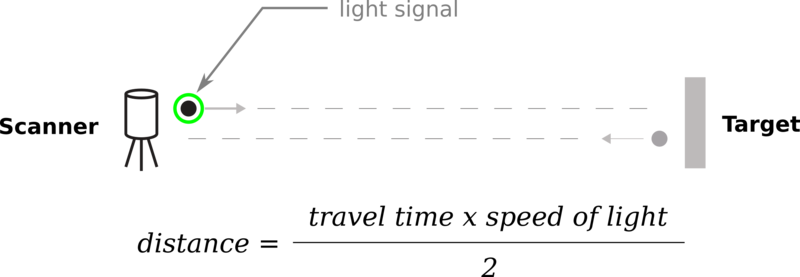
LIDAR works on the basis of measuring the time between the sending of a light pulse and its reflecting back, therefore indicating the distance of objects from the transmitting device. Thus, it is similar to echolocation. Using various types of light, it can detect hard surfaces as well as aerosols or even individual molecules, with measurements taking place on land or in the air. LIDAR technology is widely used by planes and helicopters to assist in navigation. Fitted to drones and satellites, it is used to map surfaces of the Earth or other celestial objects. It is an important tool for geology, archaeology, seismology and even atmospheric physics, as well as many other scientific and commercial fields. Recently, LIDAR technology has been applied to self-driving cars. Graph from: https://commons.wikimedia.org/wiki/File:Concept_of_LiDAR.png
LIDAR, zkratka Light Detection and Ranging nebo Laser Detection and Ranging, je metoda dálkového snímání a měření vzdáleností za pomoci laserových pulsů, skeneru a GPS přijímače a vytváření trojrozměrných modelů povrchu země nebo dna oceánu.
S pomocí technologie LIDAR vytvořili čeští a němečtí vědci virtuální mapu zaniklých vesnic na Šumavě.
LIDAR funguje na principu měření času mezi vyslaným světelným impulsem a návratem jeho odrazu, a tak zjišťuje vzdálenost objektu od vysílače. Podobá se tedy echolokaci. S použitím různého druhu světla může zachytit pevné povrchy, nebo dokonce aerosol či jednotlivé molekuly. Měření probíhá na zemi nebo ve vzduchu. Technologii LIDAR hojně využívají k navigaci letadla a helikoptéry, na dronech a satelitech mapuje povrch Země i jiných vesmírných těles. Je to důležitý nástroj pro geologii, archeologii, seismologii nebo třeba atmosférickou fyziku a mnoho dalších vědeckých i komerčních oborů. V nedávné době se technologie LIDAR aplikovala na autonomní vozidla. Graf z: https://commons.wikimedia.org/wiki/File:Concept_of_LiDAR.png
English Editorial Services’ mission is to assist international businesses and organizations of all sizes to communicate clearly, correctly, and persuasively with their business partners and target audiences.
Simply subscribe to receive our Business Term of the Day at no charge to your inbox each business day, with explanation in English and Czech.

